Projects & Experience
This page highlights key technical geospatial and remote sensing projects I have created, worked on and been a part of during my academic and professional career.
Additional links and information can be found, when available, for each example.
Geospatial Data Related Projects
Mapping Non-communicable Diseases and medication supply in The Gambia, 2024
Join project between UNOSAT and UNITAR-NCD to map, monitoring and forecast essential medicines and supplies of NCDs in The Gambia. This involved a data collection mission across The Gambia, which I was involved in preparing and undertaking.
The data collection mission included surveying and interviewing staff at different hospitals and medical facilities, capturing geodata and location-based photos.
Satellite imagery analysis for cultural heritage assessments, 2023 - 2024
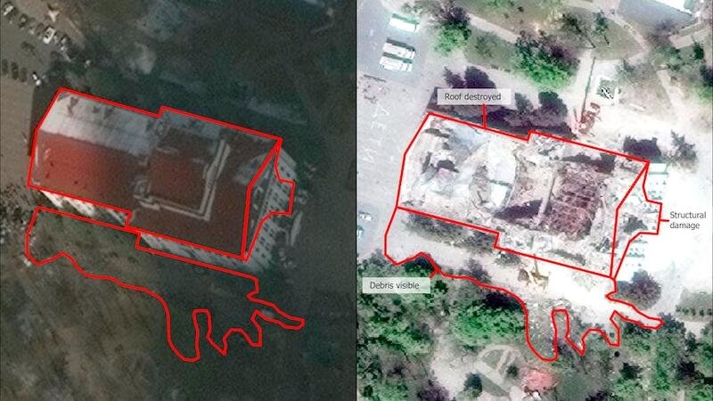
I have worked on several humanitarian emergencies, including both conflict and natural hazards, coordinating with other team members to produce rapid geographic and satellite imagery assessments for cultural heritage sites. Some of these include:
Satellite-imagery analysis, mapping and monitoring of UNESCO Cultural Sites in Ukraine
Post-damage assessment of cultural heritage sites after earthquakes, floods and other natural disasters.
Geospatial multi-criteria decision analysis tool for education site classification (UNESCO x UNOSAT Project), 2021 - 2022
I worked with UNESCO to develop a geospatial tool to assess natural hazard risks for education planning. This tool is open-source and provided for users to access via the Github link below. We also developed a technical note and methodology.
Press release: https://www.iiep.unesco.org/en/where-build-new-schools-methodology-ministries-14950
Satellite Imagery to Support Vanuatu's Electoral Project, 2021
I contributed to UNOSAT and UNDP project, using satellite imagery to map electoral areas across Vanuatu. Leveraging very-high-resolution satellite imagery we were able to identify localities with missing or inconsistent data and plan field activities accordingly.
Cartography Web Map (HTML, CSS), 2019
In my final year of Master’s studies, I developed a Cartography Web Map using both open-source and commercial software. This includes CARTO, Mapbox, leaflet, Github and HTML/CSS coding.
Mapping Humanitarian Risk, 2020
For one of my final Masters Programme assignment projects I created a web mapping application, along with a few static maps to show a map of humanitarian risk within the Asia Pacific region. I used the open-source 2019 INFORM Risk Index, which measures countries risk through six sub-categories, within three main divisions.
This web app was also accepted into the 2020 ESRI UC Virtual Gallery.
Masters Thesis, 2020
Ecosystem benefits and Pacific urban informal settlements: Does location matter? A case study on spatial accessibility in Port Vila, Vanuatu.
This research puts into perspective a local scale of a selected nine communities through a spatial accessibility study to explore where they derive their ecosystem services from.
Can be accessed on demand, please contact me.
Mapping Climate Risk for Education Planning in the Caribbean, 2022.
UNOSAT and OpenDevEd collaborated together on a project to map climate risk for education planning for Caribbean countries, in collaboration with CDEMA.
I contributed technical inputs to develop and implement a regional model safe education sector plan and National Adaptation Guide.
Satellite imagery intelligence for conflict-related emergencies, 2023 - 2024
Undertaking satellite imagery analysis and producing intelligence-based products for several conflict and complex emergency situations. This includes a range of activities such as damage assessments, site assessments, security assessments, tracking IDPs, cross-referencing ground images, identifying on-ground equipment, among other things.
Research and Publications
Geospatial Practices for Sustainable Development in East and North-East Asia 2024: A Compendium
Geospatial Practices for Sustainable Development in South-East Asia 2022: A Compendium
Geospatial Practices for Sustainable Development in Asia and the Pacific 2020: A Compendium
Asia-Pacific Plan of Action for Space Applications for Sustainable Development (2020)
Infographic representation of the Plan of Action, 2018 (lead designer)
United Nations ESCAP - Third Ministerial Conference on Space Applications - Video Development, 2018
Technical paper (lead author, 2020): Good practices and emerging trends on geospatial technology and information applications for the Sustainable Development Goals in Asia and the Pacific
Key Workshops and Conferences:
Speaker at GEO Week 2022, Side Event: Youth Track: Pannel discussion with young women in GIS
Speaker at the ESRI GIS for a Sustainable World Conference, 2022 - Geneva, Switzerland
NIES Conference, KL Malaysia (23 - 24 Jan 2018): 3rd International Forum On Sustainable Future in Asia- 3rd NIES International Forum
Speaker at the Girls in ICT day hosted by the Ministry of Digital Economy and Society Thailand the ITU, in partnership with UNESCO, FAO and CISCO - titles "Agritech Using ICTs" (27 April 2018).
Fully funded conference attendee at the World Youth Forum - Sharm El Shiek, Egypt (1 - 9 November 2018)
Scholarship recipient at the World of Drone Congress - Brisbane, Australia (26 - 27 September 2019).
Speaker at GeoRabble, Melbourne 2019
Esri GIS for a Sustainable World Conference, Geneva. Community Lightning Talks and Panel Discussion on Localization, May 2022.
Young Geographers Forum, The Royal Geographical Society of Queensland Ltd, 2022
Asia-Oceania Group on Group on Earth Observations (GEO) Symposium and GEO WEEK 2022
Activities & Courses
ABC Sweden
Humanitarian Mapping Coordinator, 2023 - 2024
Women in Geospatial (W+G) network
Oceania Regional Ambassador, 2019 - 2022
Mentorship Coordinate, 2022 - 2023
Regional Ambassador co-lead, 2022 - 2023
Mentor, 2022 - 2023
Online Courses
ESRI MOOC (Massive open, online learning courses)
April 2020 - Spatial Data Science -The New Frontier
June 2020 - Cartography
RMIT Micro-Credentials
September 2019 - Innovation for Global Cities
May 2020 - Building Cultural Intelligence
May 2020 - Developing Global Leadership
June 2020 - Global Citizen


